Why Weather Satellites Use Geostationary and Polar Orbits
Compare how geostationary and polar orbits trade repeated regional views for changing global swaths and polar coverage.
Publication & corrections: infostoa · Editorial standards
Individual author and specialist reviewer information is not provided for this article.
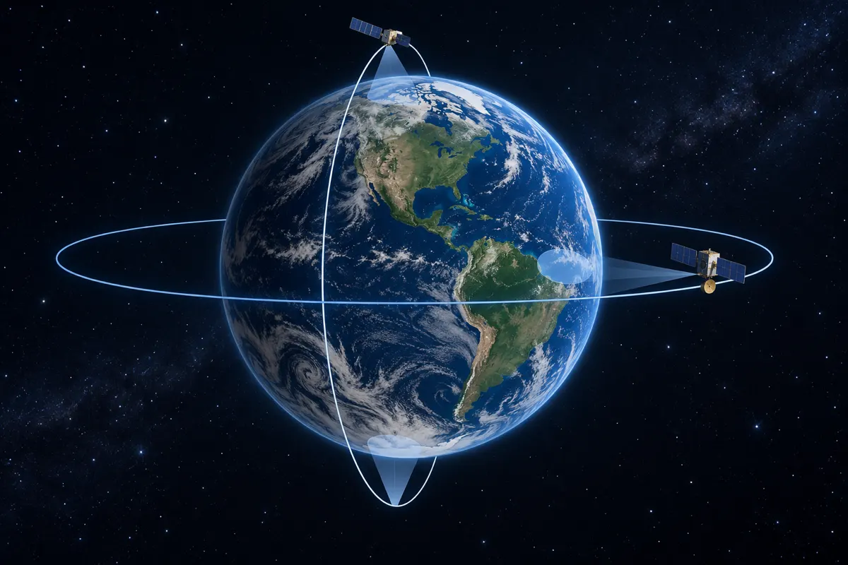
Weather satellites use different orbits because no single viewing pattern is ideal for every observation. A geostationary satellite repeatedly watches the same region, while a polar-orbiting satellite crosses different swaths as Earth rotates beneath it. One emphasizes frequent views of a fixed area; the other helps survey a wider range of latitudes.
Orbit determines the view
Satellites observe clouds, water vapor, and Earth’s surface while moving around the planet. Orbital height, inclination, and period affect where a satellite appears to remain and which places it can see at a given time. NOAA’s weather education material compares geostationary and polar orbits as two common approaches. Their trade-off begins with how the observation position changes over time, not with a claim that one instrument is universally better.
Geostationary orbit keeps one region in view
NASA explains that a circular geosynchronous orbit directly above the equator is geostationary: the satellite remains over the same point relative to the ground. NOAA describes weather satellites in this orbit as matching Earth’s rotation. That steady view is useful for frequently updating images of clouds and storms over a particular part of the planet. A single satellite does not cover the entire globe, and high-latitude regions can be near the edge of view or limited by Earth’s curvature.
Polar orbit scans successive swaths
NASA says many Earth-observing satellites use nearly polar orbits, passing from pole to pole. As Earth rotates beneath each pass, the satellite views an adjacent region on a later orbit. NOAA likewise notes that a polar satellite passes over both poles and cannot see the whole Earth at once. Flying closer to Earth can provide more detailed imagery and the orbit gives better views of polar regions, but it does not continuously watch one location.
Match the orbit to the observation task
Frequent tracking of a fast-changing storm benefits from repeated views of the same region, a strength of geostationary coverage. Broad surveys across the globe and observations at high latitudes benefit from the changing swaths of polar orbits. A polar image is not a continuous movie of the same place, so changes between passes may not be visible in a single frame. Geostationary coverage also has a limited field of view and cannot monitor the whole planet by itself.
Expert perspective: why operators use more than one orbit
NASA describes the fixed view of geostationary satellites as useful for observing weather that changes over short timescales, while nearly polar Earth-observing satellites shift their viewing swath as the planet turns. NOAA adds that polar satellites provide closer, more detailed views and better coverage of polar regions. Operators therefore weigh revisit frequency, geographic coverage, image detail, and latitude together. A satellite image is an observation of a particular place and time, not a simultaneous picture of all weather everywhere.
Read the timing of satellite images
Checking the timestamp and satellite type helps explain why a sequence of fixed-region images differs from a set of regional passes. Geostationary imagery is suited to comparing changes over the same area; polar imagery is suited to comparing successive swaths across latitudes and longitudes. Time between observations and places outside the field of view still matter, so one image cannot establish every change at Earth’s surface.
NOAA notes that the fixed perspective of a geostationary satellite allows cloud motion to be compared, and images may be recorded as often as once a minute. Frequent updates help show how a storm develops over the observed region, but cloud motion alone does not reveal every condition at the surface.
NOAA’s example of imaging as often as once per minute describes a possible high cadence, not a promise that every satellite, region, or product is delivered at that interval. When comparing geostationary frames, check both their timestamps and viewing area so the interval between observations is not mistaken for the exact timing of a cloud change. A polar-orbiting pass, by contrast, records a swath; two views of the same place can be separated by a gap. For time-series interpretation, the revisit interval matters, while broader comparisons also require the location and time of each swath.